Inertial Navigation for Civil Engineering Operations
Get more information with
Marie-Lise Duplaquet
Product Manager


Undisturbed Navigation
iXblue Attitude and Heading Reference Systems (AHRS) and Inertial Navigation Systems (INS) are Fiber-Optic Gyroscopes (FOG) based renowned for their high-end performance and reliability. Able to operate in GNSS denied, multipath or difficult environment (building, trees, tunnels, mines), they offer undisturbed navigation, accurate georeferencing, and precise pointing.
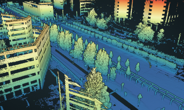
They are perfectly suited for applications such as industrial engineering (tunneling, mining, construction work…) and mobile mapping.

|

|

|

|
|
|---|---|---|---|---|
| Product type | INS + GNSS | INS | AHRS | INS |
| Typical applications | Mobile mapping / Road asset management / Precision pointing / Ground-truth | Aerial Mapping / Precision Pointing | Drilling / Tunneling / High wall mining / Road header | Drilling / Tunneling / High Wall mining / Long wall mining / Road header |
| North Finding capability | Yes | Yes | Yes | Yes |
| Heading accuracy realtime | 0.015° RMS with GNSS RTK | 0.01° RMS with GNSS Natural | 0.05° secant latitude RMS with GNSS – 0.1° secant latitude RMS no GNSS | 0.01° secant latitude RMS with GNSS – 0.05° secant latitude RMS no GNSS |
| Roll & Pitch accuracy | 0.008° RMS with GNSS RTK | 0.0025° RMS | 0.01° RMS | 0.01° RMS |
| Drift realtime without GNSS for 1 min | 0.4 m | 0.6m | N/A | 0.6 m |
| Aiding sensors | GNSS, DMI | GNSS | GNSS | GNSS |
| Postprocessing software option | Yes | Yes | No | Yes |
| Get a Quote | Get a Quote | Get a Quote | Get a Quote |
|
|
|
|
|
|
|---|---|---|---|---|
| Product type | INS + GNSS | INS | AHRS | INS |
| Typical applications | Mobile mapping / Road asset management / Precision pointing / Ground-truth | Aerial Mapping / Precision Pointing | Drilling / Tunneling / High wall mining / Road header | Drilling / Tunneling / High Wall mining / Long wall mining / Road header |
| North Finding capability | Yes | Yes | Yes | Yes |
| Heading accuracy realtime | 0.015° RMS with GNSS RTK | 0.01° RMS with GNSS Natural | 0.05° secant latitude RMS with GNSS – 0.1° secant latitude RMS no GNSS | 0.01° secant latitude RMS with GNSS – 0.05° secant latitude RMS no GNSS |
| Roll & Pitch accuracy | 0.008° RMS with GNSS RTK | 0.0025° RMS | 0.01° RMS | 0.01° RMS |
| Drift realtime without GNSS for 1 min | 0.4 m | 0.6m | N/A | 0.6 m |
| Aiding sensors | GNSS, DMI | GNSS | GNSS | GNSS |
| Postprocessing software option | Yes | Yes | No | Yes |
| Get a Quote | Get a Quote | Get a Quote | Get a Quote |
Get the Most Out of Collected Data Through our Post-Processing Softwares
| Atlans Data Analyzer | Apps with GNSS Postpro | Apps without GNSS Postpro | |
|---|---|---|---|
| Products supported | Atlans A7 Airins Phins E | Atlans A7 Airins + External GNSS Phins E + External GNSS | All iXblue INS |
| Main features | Decode raw data Check configuration Visualize navigation result: trajectory, aiding sensors | Add GNSS base stations Smart coupling GNSS+INS FW-BW optimization Calibration (lever arm and DMI) Batch processing facility | Add external GNSS data FW-BW optimization Calibration (lever arm and DMI) Batch processing facility |
| Download driver | More information | More information |
Reduce the Cost of your Industrial Engineering Operations
Mining Operations
Choosing a premium FOG INS/AHRS/IMU induces cost savings in the long run. On top of the inherent qualities of FOG (no maintenance cost, very low failure rate…), our systems’ high performance and quick bootup time means your operations will benefit from consequently lower idling time.

Mobile Mapping
A FOG IMU can measure the Earth rotation accurately and therefore offers a gyrocompass capability natively. On FOG based products, True North is found in a couple of minutes without moving by the inertial sensors aided with a one-antenna GNSS receiver. A contrary, with a pure MEMS IMU, a dual antenna GNSS receiver is required to provide the heading before moving. A FOG IMU has also a North-keeping capacity far much better than a MEMS IMU: no measurable heading drift during GNSS outages (tunnel, parking, underground…) and capacity to fly long straight lines with excellent heading accuracy for airborne applications. This is also a key feature for underground applications where GNSS is not usable and where True North is required.
FOG Powered
Premium Performance
High-performance of iXblue inertial sensors mainly relies on the mastery of the FOG (Fiber Optic Gyroscope) technology by iXblue. FOG allows to find North in any conditions and maintain heading accuracy in harsh environments. This advantage is emphasized either in pure denied environments like tunneling or mining, or in challenging georeferencing operations.
Highly Reliable Technology

iXblue core technology is used in all the company’s inertial products and is being operated in a wide range of applications. Our systems benefit from millions of working hours, and from a huge track record. The FOG core MTBF (Mean Time Between Failure) technology thus reaches over 500 000 hours.
News & Customer Stories
-

- Industry
Mandli Communications trusts iXblue’s Atlans A7 INS for its data collection operations
Mandli turns to the Atlans A7 Inertial Navigation Systems for their next generation data collection systems.Learn more -
 9 Jun 2020
- Industry
OGI selects iXblue FOG INS for new mobile mapping lidar solution
OGI, Oceanographic & Geophysical Instruments, Inc., has selected iXblue’s Atlans INS to provide robust and uninterrupted data georeferencing to its newly unveiled mobile mapping LiDAR…Learn more -
Providing Tunneling Boring Machines Unmatched Navigation Accuracy Through FOG Technology
Learn more