The iXblue’ team conducts many evaluation missions, over the world in collaboration with partners, to demonstrate the blueSeis’s measurement capabilities on seismology and volcanology, ground tomography, infrastructure monitoring and so on.
Here is a scientific publication from 2020, with measurements made using the blueSeis‐3A at the Hawaiian Volcano Observatory (USGS):
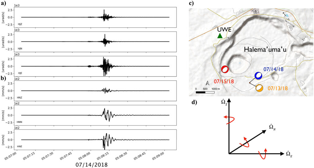
Six‐Axis Ground Motion Measurements of Caldera Collapse at Kīlauea Volcano, Hawai’i—More Data, More Puzzles?
J. Wassermann F. Bernauer B. Shiro I. Johanson F. Guattari H. Igel
Geophysichal Research Letters | First published:20 February 2020
https://doi.org/10.1029/2019GL085999
Abstract
Near‐field recordings of large earthquakes and volcano‐induced events using traditional seismological instrumentation often suffer from unaccounted effects of local tilt and saturation of signals. Recent hardware advances have led to the development of the blueSeis‐3A, a very broadband, highly sensitive rotational motion sensor. We installed this sensor in close proximity to permanently deployed classical instrumentation (i.e., translational seismometer, accelerometer, and tiltmeter) at the Hawaiian Volcano Observatory (USGS). There, we were able to record three ~Mw 5 earthquakes associated with large collapse events during the later phase of the 2018 Kīlauea summit eruption. Located less than 2 km from the origins of these sources, the combined six‐axis translational and rotational measurements revealed clear static rotations around all three coordinate axes. With these six component recordings, we have been able to reconstruct the complete time history of ground motion of a fixed point during an earthquake for the first time.